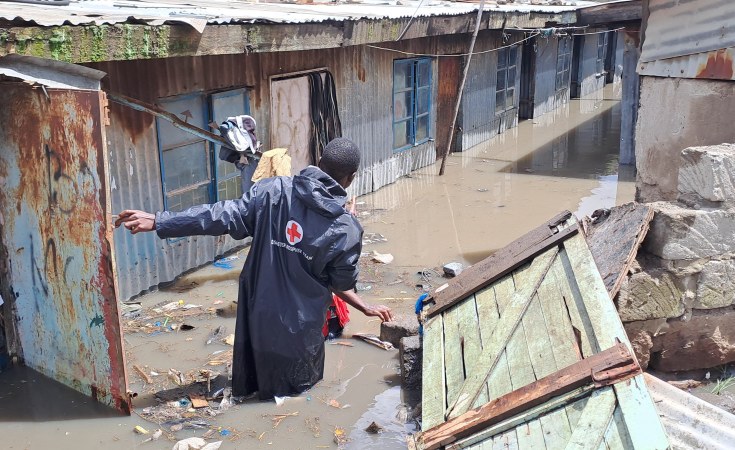
Floods in Kenya in April/May 2024 led to the deaths of over 250 people and caused damage estimated at 4 billion Kenya shillings (US$35 million).
Not for the first time, Kenya's lack of preparedness was apparent as flooding rampaged through rural and urban landscapes. There was also confusion as to who would deal with the disaster - the national or county governments. And it took several weeks before the government mobilised emergency agencies.
This need not have been the case. The Kenya Meteorological Department, the national weather agency, gave more than five heavy rainfall advisories between 1 March and 15 May 2024. This gave the government and humanitarian organisations adequate time for early actions like providing non-food items and evacuating people from informal settlements.
My research has been focused on understanding the nature, drivers and predictability of flood events in Kenya. I have also taken part in the Greater Horn of Africa seasonal forecast forums and have more than 10 years' experience as a climate scientist with Kenya Meteorological Department.
Kenya has made significant advances in the provision of weather and climate information. But there are some gaps that need to be addressed to prepare and respond better.
In my view, Kenya falls short on key points listed by the World Meteorological Organisation. These include flood forecasting, risk mapping, observation and forecasting, and communication and dissemination.
1. Flood forecasting
Efforts have been made to advance the provision of flood forecasting by the Kenya Meteorological Department. Kenya relies on heavy rainfall advisories provided by the national weather service and by the Climate Prediction and Application Centre of the regional Intergovernmental Authority on Development. Rainfall greater than 50mm in 24 hours is in most cases used as a proxy for flood early warning and preparedness. These alerts contain information on areas (counties) that are likely to receive such rainfall and be affected by flooding.
Some scholars have questioned the appropriateness of heavy rainfall advisories for flood preparedness. But I believe they had value for both government and humanitarian organisations during the recent flood events in Kenya.
A far more accurate tool is a system that predicts the occurrence, magnitude, timing and duration of floods in a specific area. Kenya has 21 documented areas that are prone to flooding.
Each of the 21 hotspots should ideally have a flood forecast system, but only one exists: for the Nzoia river in the Lake Victoria basin. Flood forecasts here are provided three days in advance.
There are no operational flood forecast systems for Kenya's cities, including Nairobi and Mombasa. There is therefore a need to expand early warning systems to cover areas identified by the national masterplan.
2. National risk mapping
There is limited knowledge of the most flood prone areas across the country, which poses a challenge during flood preparedness and response. Exposure and vulnerability can change, too. Better flood risk mapping is needed across the country through use of Earth observations and high resolution elevation data.
These would map the elevation of water courses - information that falls under the Water Resources Authority through technical support from the Kenya Water Security & Resilience Project. The river elevation information can then be combined with population settlement data and flood forecasts provided by Kenya Meteorological Department. This would then inform impact based forecasting, a shift from what the flood will look like to what the flood can do.
3. Observation and forecasting
All forecasts are as good as the amount and quality of observed data. The density of hydro-meteorological networks in Kenya, as in the rest of Africa, is relatively low, with only 38 land based weather stations, which is barely 12.5% of the minimum recommended density.
There are efforts to increase the density of the African network but more investment will be needed. Kenya also needs to invest in weather radar observations which can detect heavy storms. This is especially useful for urban centres such as Nairobi.
Using global flood forecasts of up to 30 days, such as Copernicus (password required), would add to the information for early preparedness actions.
4. Communication and dissemination
There are standard World Meteorological Organisation international guidelines for dissemination of extreme events such as floods, referred to as Common Alert Protocol. Kenya uses these but there are still gaps in warning communications to reach those at risk of flooding. In 2024 Kenya Meteorological Department issued early warnings which were disseminated through various media including its X (Twitter) handle.
More stakeholder awareness activity ought to have been undertaken in order to communicate the potential of such early warning systems. There is therefore a need for co-design of communication products, diversification of communication channels, regular monitoring and feedback and collaboration among agencies and stakeholders.
Next steps
Getting these steps right doesn't guarantee the right emergency response. Kenya has only recently developed a so-called "early action protocol" which outlines specific information on who does what during flood anticipation actions.
The County Disaster Management Act requires that the 47 county governments make provisions for funds for disaster preparedness and response in their annual budgets. This should be scrupulously enforced and supplemented by both levels of government.
Finally, Kenya should consider establishing a legally mandated institution for managing the response to flood disasters, in much the same way as the National Disaster Management Authority oversees drought emergencies.
Augustine Kiptum, Research Student, School of Global Studies, University of Sussex


