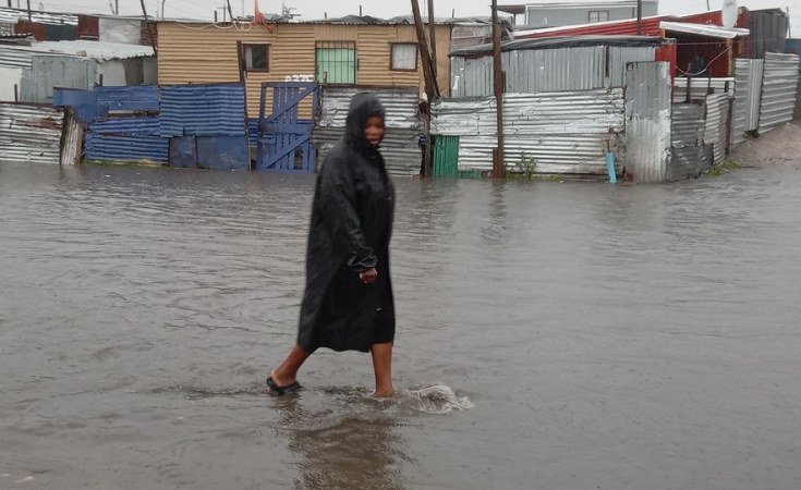
The Provincial Disaster Management Centre (PDMC) received reports from the various districts as well as Western Cape Government (WCG) departments earlier today after the first of several intense cold fronts made landfall over the past weekend. “Widespread disruptions and damages including loss of shelter in informal settlements, localised flooding, fallen trees, electricity outages, and road closures due to snow or flooding, were reported during our meeting today. The City of Cape Town, Overberg, Cape Winelands, and West Coast Districts were hardest hit by the severe weather. As always, our focus remains on the safety of our residents and the humanitarian support that they need,” Anton Bredell, Western Cape Minister for Local Government, Environmental Affairs and Development Planning said.
Minister Bredell said the Provincial Government is working together with the City of Cape Town and the National Department of Human Settlements to address the immediate needs of people who have lost their homes during the storms.
Significant rainfall has been recorded for the period between Sunday and Monday: Ceres receiving 123mm and Elgin Grabouw received 84mm. Observatory in Cape Town recorded 47mm, and Stellenbosch measured 68mm for the same period.
The South African Weather Services (SAWS) provided an update on what can be expected from today until Friday. A series of cold fronts are still on track to make landfall, resulting in a week of wet and cold conditions. Today will see the coldest daytime temperatures, and the next cold front with rain is expected to arrive on Tuesday. Between 10 and 20mm of rain is expected over the western parts, and between 40 and 60mm can be expected over the southern western mountains. “We are concerned about the rain-on-rain scenario, as saturated soil could lead to rock falls, landslides and flash floods,” Minister Bredell said.
Sign up for free AllAfrica Newsletters
Get the latest in African news delivered straight to your inbox
Premier Alan Winde added, “I want to commend all stakeholders who have been ably coordinated through the PDMC for all their hard work in responding to the severe weather. We have built up capacity across our disaster management system to deal with such events, prioritising the protection of lives and ongoing humanitarian relief efforts.”
SAWS confirmed its outlook for strong to gale force west to north-westerly winds for the south-west coast and emphasised the high danger of runaway wildfires in the Garden Route District.
The Department of Water and Sanitation continues to monitor river and dam levels, which are expected to rise significantly in the coming week.
The PDMC will support several search and rescue operations to communities currently cut of from main access roads. “Wuppertal and other communities in the Cederberg area will be reached by specialised 4x4 teams once a needs assessment has been conducted, and we will be ready for similar requests as the week unfolds,” Minister Bredell said.
Eskom reported several outages over the past 48 hours caused by the severe weather. Cape Town, the West Coast and Overberg regions were hardest hit so far, and repair teams are attending to them as fast as possible. The PDMC is monitoring this situation if it impacts on critical government services.