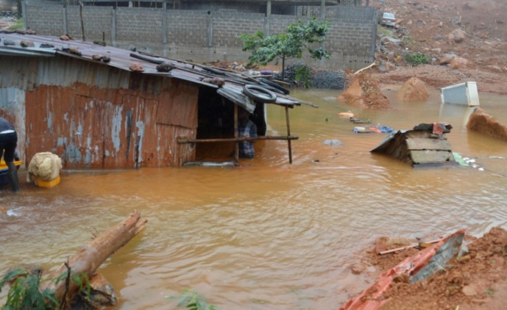
On August 14, a severe landslide/mudslide and rainstorms disaster killed hundreds on the outskirts of Sierra Leone's capital Freetown.
It is believed that the mudslide and floods occurred after three days of torrential rain which overwhelmed the inadequate drainage system of the city, creating waterways that turbulently flow down steep streets across the capital.
Freetown is a beautiful landscape-coastal city situated in mostly unplanned swathes of land between the mountains and the Atlantic sea. Like other Mano River Union countries, Sierra Leone have an equatorial climate splits into two seasons: rainy and dry seasons.
The rainy season is characterized by occasionally exacerbating flood events and peak hourly flow between June and August. Like most West African cities, Freetown is also plagued by unregulated building structures, residential houses in hilltop areas and unplanned settlements.
Keep up with the latest headlines on WhatsApp | LinkedIn
Urban informality is visibly present. Looking at the videos and photos from the flooding events, this brief write-up therefore seeks to examine and throw light on some of the probable causal factors that may have triggered the recent disaster.
In a case study paper presented at Stuttgart University, Germany, on flooding and minimization strategies in unplanned urban communities of Monrovia, Liberia, I argued that the lack of a coordinated storm water drainage system contributes to severe flooding; and other causal factors include, poor urban planning; urbanization; haphazard dumping of solid waste.
These are all factors complicit in the recent event in Freetown.
In addition to the above factors, climate change too does play a major part. It is expected that climate change will lead to more variable patterns, shorter and more intense rainy seasons, increase in storm frequency and temperature, thus increasing the potential for floods.
Freetown seems to be experiencing changes consistent with these expected trends in climate change.
Causal factors - Lack of coordinated storm water drainage system
Urban drainage system is thought to handle two types of water with the aim of minimizing risks caused to human and the environment: storm water and wastewater.
Therefore, a well-designed drainage system is key to reducing threat to human and the environment, but this remains one of the most pressing issues affecting most African cities at the time of this writing.
The growing number of informal settlements along mountain sides and downtown Freetown comes with the side effect of inadequate and poorly-engineered drainage systems.
Further, urban drainage design processes often require rainfall intensity data due to the fact that rainfall is responsible for peak flow in storm sewer network.
This can be obtained by measuring the depth of rain that falls over a specified catchment area.
It is then the main input data and parameter for pipe, drainage and canal sizing. From the flow of storm water as seen in videos, it is possible that most of the drainage network in the city has not been properly designed to the specificity of extreme rainfall events periodically occurring in the city.
Poor urban planning
The visible absence of proper urban planning in most developing countries is arguably the key culprit of urban flooding in African cities.
Improper housing development, poor municipal oversight on land use and city ordinance in municipalities, often lead to building of homes, expansion of commercial properties and industrial developments in reclaimed wetlands where floodwaters use to drain, thereby increasing flooding in communities.
Corruption and lack of municipal enforcement policies also often lead to wealthy citizens to discretionarily build properties that tend to block drainage channels and natural water streams. This cannot be overemphasized when one takes a look at the Bushrod Island community of Monrovia, and hillside communities in Freetown.
Urbanization
In urban hydrology, urbanization means more paved surfaces (impervious) than unpaved surfaces (pervious). This means urbanized areas yield more runoff than vegetated land. Simply put, this makes water (surface runoff) travel faster, forceful, and in huge quantity, from upstream to downstream.
Therefore, urbanization aggravates flooding by restricting where flood water can go, by covering large parts of the ground with roofs, roads and pavements, by obstructing sections of natural channels (ActionAid Report 2008).
Haphazard dumping of solid waste
Inadequate waste management system and haphazard disposal of solid waste has been reported as one of the key causes of flooding in poor urban areas in Africa (Douglas et al. (2008). Residents in poorly laid out areas most often dispose waste into the drains and natural streams, contributing further to the increase in flooding when it rains heavily.
Landslide /Mudslide
Landslide is a general term used to describe the down slope movement of soil, rock, and organic materials under the effects of gravity (The Landslide Handbook-USSG). In terms of causal factors, it can be due to ground conditions (weak, weathered material etc); geomorphological processes (erosion at the toe of the slope etc.); physical processes (earthquake, volcanic eruptions, intense or prolonged rainfall etc.); man-made processes (excavation, road construction, mining, quarrying etc).
From the disaster in Freetown, it's sufficient to surmises that most of the above factors may have rendered the soil unstable and more vulnerable to collapse; thus, the torrential flood was just an immediate trigger that led to the mudslide.
In most developed countries where hill or mountain sides are used for housing development, some level of engineering interventions ---like construction of retaining walls at the toe to slow or inhibit soil movement, adequate drainage along hill to prevent water buildup in slide mass etc.---are required as safety nets.
These kinds of engineering interventions are visibly absent along the hill sides in Freetown.
Recommendations
Preventive coping strategy is one approach poor urban dwellers use by avoiding to build in flood-prone areas; while Impact-minimizing strategies are those which minimize loss, and facilitate recovery Blaikie et al. (20049).
In this piece, I add that a comprehensive approach from both municipal and central government is needed to remedy the situation; this therefore leads us to the following recommendations:
Mapping of all flood-prone areas in the city and continuously updating such record. The maps should contain detailed information on flooding. Also, the need for accurate and reliable national data on rainfall events and strengthening of research capabilities etc.
Comprehensive diagnostic study of the existing storm water networks and rehabilitation mechanism to be conducted in Freetown, as the present hydraulic capacity seems far below the demand (current population exceeds designed population)
Medium -to Long-term solutions that involve urban upgrading and major structural works that require relatively large capital projects that include construction of huge canals along flood-prone areas or plains to capture storm water and transmit to receiving water bodies or retention facilities.
Enforcement of municipal laws on planning and urban development. Most municipalities of our region seem lax in enforcing municipal ordinances something contributing to sprouting of illegal buildings and communities which become more susceptible to flooding, disaster and diseases.
The inclusion of informal settlements in the city's waste management programs
Government reform of housing policy to compel local communities and landlords to provide homes with drainage systems and other sanitation facilities that are well-connected to centralized storm and sewer networks.
Education and sensitization of communities; advocacy with government and policymakers to draw attention to the plight of residents in poor and flood-prone communities; have a permanent workforce to maintain and clean the drainage; and adoption of green concepts.
In case of landslide/mudslide, common preventive measures include leveling, proper grading, engineering of drainage pathways to prevent future water buildup in the slide mass and construction of retaining walls at the toe to slow or deflect the moving soil. These measures tend to reduce gravitational and seepage forces which cause instability in natural slopes that lead to landslide. Also, Instrumental monitoring and geomorphological mapping to detect movement along and research work can be implemented. However, the best mitigation is to avoid development activities near steep mountain slopes that are not well engineered.
The above mentioned casual factors and recommendations can be extrapolated to most countries in our sub-region. Adopting carefully tailored, sustainable and comprehensive medium to long-term solutions that involve urban upgrading and major infrastructural works that require relatively large capital expenditure at municipal and central government level will be very helpful. Regional collaborations through centralized disaster prevention and mitigation strategies must also be sought. Our hearts and thoughts are with the people of Sierra Leone!
Muniru Nyei, Civil Engineering


